
Porters Creek Trail
Gatlinburg, Tennessee
Rated 5.0/5
based on 1 reviews
5.0/5
Details
Distance
7.19 miles
Elevation Gain
1614 ft
Route Type
Out-and-Back
Description
Added by Outbound
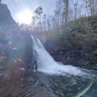
Porters Creek Trail is an out-and-back trail that takes you by a waterfall located near Gatlinburg, Tennessee.
Download the Outbound mobile app
Find adventures and camping on the go, share photos, use GPX tracks, and download maps for offline use.
Get the appFeatures
Camping
Running
Backpacking
Hiking
Family Friendly
Forest
River
Scenic
Wildflowers
Wildlife
Waterfalls
Porters Creek Trail Reviews
So great! Didnt make it to the falls part due to running out of daylight. Highly recommend! Will do it again!
5.0
Leave No Trace
Always practice Leave No Trace ethics on your adventures and follow local regulations. Please explore responsibly!
Nearby

Fern Branch Falls
Take Porters Creek Trail, a gravel road alongside Porters Creek. You will pass by an old farmstead and cemetery, as well as lots of wildflowers if you're out during the spring.
In a mile, keep left, then in another half mile or so you should cross over a small (and somewhat harrowing) footbridge. The 40-ft tall Fern Branch Falls is less crowded than other falls in the park, and has open access...

Hike to the Ramsey Cascades
This multi-tiered waterfall is known as the tallest in the park – a worthwhile reward for the steep and sometimes tricky terrain you'll face on the way up.
The popular route to the falls also passes through an impressive old-growth forest, which apparently boasts some of the tallest trees in the park. You will also see smaller waterfalls and pools along the way.
Keep in mind that about 2 mile...

Grotto Falls Trail
This is an intermediate hike along Trillium Gap Trail. There are four stream crossings on your way to the falls as you hike through an idyll, often wildflower-sprinkled landscape. Late spring is best for catching blooms. Once at the waterfall, you can walk behind the cascade of water.
This is a popular hike, so be sure to arrive early. In the winter, you will need to access this hike via the R...

Mount LeConte-Cliff Tops via Rainbow Falls Trail
Begin at the Rainbow Falls trail parking lot. This is very popular area especially in the summer. If the parking area at the trail head is full there is additional parking located just past the main lot. From here the Rainbow Falls trail is just under 14 miles to the summit of Mount Leconte. Elevation gain is steady but relatively steep.
The trail opens along a fairly rocky and rooty traverse ...

Roaring Fork Motor Nature Trail
This 6 mile drive is a great way to spend a scenic day in the Smokies. The road is open to cars only (no trucks or RVs) and runs one-way. There are no visitors centers after you head out, so be sure to bring everything you need along.
The drive begins at the historic Ogle farmstead, which is also the location of the Rainbow Falls Trailhead (5.4 miles). Further along you will find the Trillium ...

Photograph the Smokies from Morton Overlook
The Morton Overlook is one of the Great Smoky Mountains National Parks most well known and visited overlooks. Morton offers a wide view of the Great Smoky Mountains and is a perfect spot for some really good photography opportunities. Coming from Gatlinburg, TN it is roughly 13 miles from the visitors center along 441 towards Cherokee, NC.
Sunset is the best time of the day for color in the ski...
Community
Mobile Apps

© 2025 The Outbound Collective - Terms of Use - Privacy Policy