
Sturtevant Falls
Arcadia, California
Details
Distance
1.61 miles
Elevation Gain
423 ft
Route Type
Out-and-Back
Description
Added by Outbound
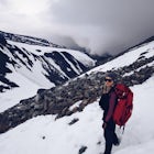
The trail to Sturtevant Falls is an out-and-back hike with minimal elevation change. Enjoy the sounds of the creek as you trek toward this 60ft waterfall. This is a dog-friendly hike.
As you head down to Roberts Camp, a historic set of historic cabins, you’ll head out on a steep, paved road for approximately 0.6 miles. Once you reach the camp, head over the bridge and keep an eye out for the sign for the Gabrielino Trail, which will take you to the falls.
Along the trail, you’ll have to cross the creek a few times. After almost a mile and a quarter, you’ll reach the falls. Relax, unpack the lunch or snacks you hopefully remembered to throw in your backpack, and enjoy. When you’re ready, head back the way you came.
Note:
This area had been closed since September of 2020 due to the Bobcat Fire. This trail reopened in October 2024 (source). Pack out what you pack in and please focus on maintaining this area so it can stay open.
Parking Pass:
An adventure pass is required and should be displayed when parking at trailheads in Angeles National Forest. Learn more at FS.USDA.GOV.
Download the Outbound mobile app
Find adventures and camping on the go, share photos, use GPX tracks, and download maps for offline use.
Get the appFeatures
Sturtevant Falls Reviews

The review that states that the gate is closed is wrong. Therefore statement that it is six miles is incorrect. After the parking gets filled up to full capacity, then only they may close the gate which shows how popular the hikes are in chantry flats area. There are many different hikes you can take from Chantry If gate is closed you can come back in a few hours and it will be open as people will start leaving Sturvant falls is easiest hike. Mostly, flat -walking next to stream of water all the way.
5.0
The gate is closed at the end of the housing at Santa Anita so the hike is 9 miles round trip to the falls... but the parking is free
3.0

Gorgeous And Easy Hike To The Falls. Absolutely Beautiful Scenery The Whole Time You're Basically In The Shade And The Falls At The End Is Incredible
5.0

This is my go-to hike after it rains, when the waterfall is at its best. Make sure you come early, parking gets filled up really quickly and most people are forced to park on the windy road leading up to the trailhead. There is also a cute little general store near the trailhead you won't want to miss!
4.0
I have to say that is was absolutely my favorite hike in Southern California. I lived in the Pacific Northwest for years and the absolutely breathtaking hike you take to the falls is just amazing. It's lush, green and the air has a fresh and untouched essence that is enough to make you never want to leave. When I had initially embarked on this trip I did a "3 waterfall" trip (Ortega falls, sturtevant falls, & Escondido falls) and all of them were completely dried up with the exception of this one. It made the entire trip worth it! Plus, like I always say, it's a bonus anywhere I can hike with my dogs!
5.0

What a hidden little gem near the city that I would never have expected! Relatively easy hike and beautiful falls at the end! The toughest part is the hike back up.
5.0
Leave No Trace
Always practice Leave No Trace ethics on your adventures and follow local regulations. Please explore responsibly!
Nearby

Mt. Wilson Loop from Chantry Flat

Hermit Falls Trail

Monrovia Falls

Eaton Canyon Falls via Eaton Canyon Trailhead

Eaton Canyon to Idlehour Trail Camp

San Gabriel Peak
Community
Mobile Apps

© 2025 The Outbound Collective - Terms of Use - Privacy Policy