
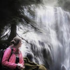
Spirit Falls
Cook, Washington
Details
Distance
1.5 miles
Elevation Gain
516 ft
Route Type
Out-and-Back
Description
Added by Angela Service
Take in this scenic waterfall with turquoise blue water. If you're lucky, you may see kayakers running the falls.
NOTE: Access to this hike is currently closed. A Part of this hike goes through private land. At this time, the landowner is not granting access to hikers.
There are no signs or trail head for the falls, but it's a popular spot for kayakers and photographers, so look for a faint boot path directly from the pulloff on Cook Underwood Road and follow it to the river.
The hike is short, but very steep, down a talus slope of loose rock and moss. There are sudden drop offs near the falls, so it is better to leave children and dogs at home. The climb/scramble back up to the road will definitely get your heart pumping.
Download the Outbound mobile app
Find adventures and camping on the go, share photos, use GPX tracks, and download maps for offline use.
Get the appFeatures
Spirit Falls Reviews
So so beautiful in the winter to hike, I did this last January and I wanna kayak it next winter!!
5.0

Kind of a bummer, but someone bought the land around it so it's on private property now. We tried to go around the signs, but couldn't make it through some of the forest. I'd try asking the owners if anything.
3.0

The area she parked at was approx 10 yards south of mile marker 2 on Cook-Underwood Road. There's a clearing facing south where you can see toward OR. There's a trail headed straight down there. To avoid private property issues and parking hassles. Enjoy and be safe !
5.0
This location is on Private property. Go speak with the land owners first. They are willing but wish you speak with them first and sign a release form because the loose rocks are dangerous and there are rattle snakes in the rocks. So it is very dangerous to be accessing and they don't want liability.
2.0
Didn't see of these signs that ppl are talking about in the comments but had a great time! Snow was probably 2 feet deep & followed the path from others before. Crampons + gloves recommended. Be safe when you get down there!
5.0
A portion of this hike has been closed to hikers recently as they have been accessing the falls through private property. If you head a little further up and drop down away from the signs you should be okay. Always use caution and know your limits as a hiker as this is off trail and a very steep slope down to the river.
5.0
Leave No Trace
Always practice Leave No Trace ethics on your adventures and follow local regulations. Please explore responsibly!
Nearby

Warren and Lancaster Falls

Mount Defiance

Lower Starvation Ridge Loop

Starvation Creek Falls

Dog Mountain: The Steeper Route

Dog Mountain via Dog Mountain Trail
Community
Mobile Apps

© 2025 The Outbound Collective - Terms of Use - Privacy Policy