
Bernardo Mountain Summit Trail
Escondido, California
Details
Distance
7.15 miles
Elevation Gain
1060 ft
Route Type
Out-and-Back
Description
Added by Robb Keele
This hike to Bernardo Mountain Summit, part of the growing Coast to Crest Trail, features amazing views of the lake and surrounding mountains. It's dog and family-friendly (for older kids), so pack up all your little ones.
Bernardo Mountain is located on the Coast to Crest Trail in San Dieguito River Park.
The 7.15-mile out-and-back trail to the 1060 ft. summit starts on the east side of I-15. It's a relatively easy hike all the way to the top. It picks up a little once you make it to the Summit Trail junction, where you will begin to gain some elevation. But even this part of the trek isn't all that difficult if you're in moderately good shape.
At the base of the mountain, you're welcomed by the Lake Hodges nature preserve, a beautiful lush, green area that even has a palm tree lined oaisis with a small creek running through it. Further up, the trail becomes more typical of other trails in San Diego with the dense vegetation and chaparral we're all familiar with. At points, the trail overlooks the houses of lucky homeowners whose backyards butt up against the preserve. If you start to feel like your prying eyes are unwelcome, simply look back to the trail ahead and your attention will once again be nature bound.
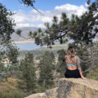
Once standing atop the peak, you will be rewarded with stunning views of the surrounding hills and mountains. Mt. Woodson and Iron Mountain are both visible to the east, and Black Mountain to the South, and Lake Hodges sitting in between.
And remember to sign the summit register to let everyone know what you accomplished on this day.
Download the Outbound mobile app
Find adventures and camping on the go, share photos, use GPX tracks, and download maps for offline use.
Get the appFeatures
Bernardo Mountain Summit Trail Reviews
Great hike with an amazing view. Took a few hours but was definitely worth it. It's very easy to miss the summit trail head. The sign is facing west on the trail and you come up to it from the east side so it's very easy to pass.
5.0

It's a long hike, but the view at the end is worth it
5.0
Leave No Trace
Always practice Leave No Trace ethics on your adventures and follow local regulations. Please explore responsibly!
Nearby

Battle Mountain's Cross

Blue Sky Ecological Reserve to Ramona Dam

Lake Hodges Overlook

Lake Poway

Mount Woodson and Potato Chip Rock

Black Mountain Peak via Miner's Ridge Loop Trail
Community
Mobile Apps

© 2025 The Outbound Collective - Terms of Use - Privacy Policy