
Danielle Tourigny Explorer
Maine resident and Emergency Medicine PA-C with a love of all things nature. Traveling around to find the most beautiful spots and most delicious eats.

Freedom Trail
Boston, Massachusetts
4.7
2.9 mi
/ 121 ft gain
Park along the trail and then hop on. The Freedom Trail allows you to not only see the most beautiful parts of Boston (which is an absolutely gorgeous city) but you can learn some history too! Head off the trail a bit to explore the Charles River, the waterfront near the aquarium and picturesque Beacon Hill. If you have a nice day and want an easy way to see the best parts of Boston, this is de...

Hike The Skyline Trail at Blue Hills
Quincy, Massachusetts
4.0
12.7 mi
/ 2542 ft gain
Park in the lot across from Batterymarch Rd off of Willard St. Access the Skyline trail from here, it is marked blue. Follow the signs. The trails in Blue Hills are perfect for training for backpacking because they are so steep and rocky. I would fill up a big pack and take the skyline trail up to the gorgeous views at the top. It is forested and leads past a couple of bodies of water. A perfec...

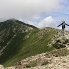
Summit Mount Hancock and South Hancock
Lincoln, New Hampshire
9.8 mi
/ 2220 ft gain
The Hancock trailhead is located at the infamous hairpin turn of the Kancamagus Highway in the White Mountains. The trail itself crosses the road and starts at 2000 feet of elevation on the Hancock Notch trail. It remains fairly flat for the first 3 miles of the trail. After 1.8 miles you will hit the first junction with the Cedar Brook Trail where you will take a left. Continue for another 0.7...
")
Hike the Grand Canyon of Maine (Gulf Hagas)
Brownville, Maine
8.6 mi
/ 1000 ft gain
Find the trailhead by turning left at the Brownville junction and then turning left onto Katahdin Ironworks Rd. This is a well maintained dirt road (had no trouble getting down it with a Corolla). There is a checkpoint where you need to pay a day use fee. When I went summer 2018 it was $9 per person for Maine residents and $14 per person for out-of-staters. It seems steep, but I promise on a ni...

Cross Country Ski the Trails at Harris Farm
Dayton, MaineHarris Farm is a great place for beginner cross country skiing or to hone in on already developed skills. They provide rentals ($15pp) and the network of trails is several miles long. The trails range from green (easy) to red/black (more difficult). I personally love hanging out on the blue trails that are moderately difficult and have plenty of hills winding through forest and meadows. The ent...

Hike Eyebrow Trail to Old Speck Mountain Loop
Maine 26, Maine
7.8 mi
/ 3000 ft gain
The first time I attempted this trail was in mid April, and the slush and mud I encountered was absolutely unbelievable. Snowshoes were useless. Crampons were useless. Boots alone meant dirty, wet, muddy feet. So, I had to bail. But I came back in October and I’m so glad I did because the views of the foliage were amazing!
The Old Speck Trail very quickly hits an intersection with the Eyebro...

Snowshoe Mount Jackson
Crawford Notch Road, New Hampshire
5.2 mi
/ 2300 ft gain
The hike starts across the street from the AMC Highland Center on route 302, which means there is plenty of parking and when you finish there is a fireplace and snacks to warm up with! It starts at the Webster Jackson trailhead and after 1.4 miles breaks off onto the Jackson trail. At that point you could take the Webster trail to create a loop that summits Webster and Jackson, but after the 3 ...

Run the Jamaica Pond and Victorian Jamaica Plain Loop
Boston, Massachusetts
5.0
1.5 mi
/ 95 ft gain
Park in the Jamaica Pond parking area. You can go either direction on this loop trail, which is highly trafficked and dog-friendly. Keep a lookout for (and a respectful distance from) the wildlife that live here. The loop around Jamaica Pond itself is 1.5 miles. The best part about running in this area is that it links up to so many other running trails. It is a part of the Emerald Necklace whi...

Run the Arnold Arboretum Trail
Boston, Massachusetts
5.0
2.6 mi
/ 150 ft gain
Park in the lot off of Arborway to access the trail. This place is gorgeous year round. The winter offers a quiet solitude, fall boasts bright colors, spring is the most beautiful as the flowers start to burst and cherry blossoms take over, and summer is overwhelmingly green. There are dozens of spots around the arboretum where you can just nestle under some trees and have a private picnic or m...

Osceola Mountain via Greeley Pond
Lincoln, New Hampshire
4.0
6.8 mi
/ 2677 ft gain
Start out at the Greeley Pond trailhead off of the Kancamagus Highway. After 1.3 miles the trail splits--bear right to get onto the Mt. Osceola Trail. Continue 1.5 miles to the summit. This summit hike offers a different kind of reward. Views are limited from the peak of Mt. Osceoloa, which allows you to focus on your immediate surroundings. Enjoy the fresh mountain air and the gorgeous trees r...

Mount Battie
Camden, Maine
5.0
1.07 mi
/ 512 ft gain
The summit of Mount Battie is accessible from either the front trail that is located just outside of the state park, or there is an auto road that leads up to the summit within the park (the location drop pin reflects the route within the park).
To access the front trail, the trailhead is on mountain street where there is a small parking lot available. The auto road is usually closed in winte...

Photograph West Quoddy Head Lighthouse
Quoddy Head State Park, MaineWe started our adventure in this area by backpacking the Cutler Coast (adventure to come on this)! After our night in the backcountry we drove 20 minutes to the adorable town of Lubec. At West Quoddy State Park, you are able to walk around the cliffs to get views of the Canadian border and see the brightly colored lighthouse that is a photographer's dream against a cloudy backdrop.
We stopped ...

Summit Dorr Mountain via the Ladder Trail
Bar Harbor, Maine
5.0
3.24 mi
/ 1125 ft gain
To find the trail head, drive out of Bar Harbor down Route 3. There are no signs for the trailhead or for parking, so as soon as you pass Tarn Lake on the right, you can pull off and park on the side of the road.
Elevation on the ladder trail starts immediately and doesn't let up until you reach the summit, which is the downside of summiting a 1200ft mountain in one mile. The trail is 90% rock...

Hike Mount Megunticook in Camden Hills State Park
Camden, Maine
2.9 mi
/ 1000 ft gain
After driving in to Camden Hills State Park, there is a fork where you can go straight (to the campgrounds) or left (to head up Mount Battie). Take a left and then park in the parking lot immediately on your right. That is the trailhead to Mount Megunticook!
The trail itself winds through the trees, slowly gaining elevation. There is a point where the trail forks into two. Both options will get...

Hike to Jewell Falls
Portland, Maine
4.5
2 mi
/ 300 ft gain
Fore River Sanctuary is 85 acres in the heart of Portland right off of Congress Street. It is a unique place where the river meets the ocean and creates a marshland landscape, which provides a plethora of opportunities to see wildlife (especially a great diversity of birds - waterfowl, herons, egrets, etc). Upon entering the south entrance near the MaineOrtho parking lot, you are hiking on what...

Explore the Hopewell Rocks
Hopewell Cape, New Brunswick
4.5
Hopewell Rocks (otherwise known as the flowerpot rocks) are in the Bay of Fundy, New Brunswick. Not only does the Bay of Fundy boast the highest tides in the world, but the 40-70 ft rock formations formed by the tide are incredibly unique. At low tide, you can walk on the sea floor that is four stories under water at high tide. High tide has its own benefits because you can kayak around the roc...

Backpack Cutler Coast
Trailhead: Cutler Bold Coast Trail, Maine
9.6 mi
/ 0 ft gain
This is a great hike for beginner backpackers! We were able to successfully complete it with our 4month old puppy!
At the trailhead, there is plenty of parking and an outhouse. We took the coastal trail to the ocean and continued along the Fairy Head Loop: This trail provides the most extensive shorefront hiking with 3.8 miles that skirt the shore. The backcountry sites are at Fairy Head just b...

Hike Southern Middlesex Fells Loop
Medford, Massachusetts
4.7
3.5 mi
/ 756 ft gain
Park in the parking area near Bellevue Pond. There are multiple entrances to the reservation (some closer to the reservoir itself than others). I have spent days in there hiking around and never seeing the water and there are days when I just hiked right in to the water and sat and enjoyed it. The trails are perfect for mountain biking as well. I spent so much time here when I lived in Boston b...

Photograph Screw Auger Falls
Newry, Maine
4.0
0.2 mi
/ 6 ft gain
After parking in the allotted parking area at screw auger, make your way down to the falls to explore! There are several "smaller waterfalls" that the river flows over before making its way to the 27 foot main attraction. Going in April, the falls were at their most powerful. It made taking pictures a little difficult because I was being nailed with water the whole time, but it was also incredi...

Cathedral Ledge
Bartlett, New Hampshire
4.0
0.31 mi
/ 95 ft gain
During spring, summer and fall there is a road that allows you to drive to the top of Cathedral Ledge. In winter the road is closed off to vehicles so reaching the top requires a 1.7 mile hike. Once at the top, there is a fenced in lookout with a 180 degree view of North Conway and the surrounding mountains. There is also a gorgeous aerial view of Echo Lake.
Cathedral Ledge also has a plethor...

Photograph Lepreau Falls
Lepreau, New BrunswickThe interpretive trail offers several different vantage points of the falls, and they are all equally beautiful. It was pouring rain while we were there, but it didn't stop me from running around for almost 45 minutes taking pictures and enjoying the views because these falls are so beautiful.
There is a daytime picnic area near the water that is nice, and there is also an option for overnight ...

Hike Bald Mountain in Rangeley
Bald Mountain Road, Maine
2.3 mi
/ 931 ft gain
The trail itself has a gradual incline over the course of the 1.15 miles to get to the top. There are a few steeper sections near the top, but completely manageable even for a beginner. There is another trailhead off of route 4, which would lead to a longer hike, around 4 miles. When coming from Bald Mountain Rd, the intersection with the trail on route 4 is the only intersection you will come ...

Sargent Mountain via South Ridge Trail
Mount Desert, Maine
6.76 mi
/ 1293 ft gain
This has been one of my favorite winter adventures that I have had in a long time. There were gorgeous views of Somes Sound, we saw three snowy owls and there is a gorgeous frozen waterfall on the way up to the summit!
Because much of the Park Loop Road is closed in winter, we started our hike from a Parking area off of Route 3 (It's the one just north of Upper Hadlock Pond and you have to cr...

Hike up to Maiden's Cliff
Camden, Maine
2 mi
/ 1000 ft gain
With a total elevation gain of 1000 feet in one mile to the top, the entire hike is uphill. The whole hike is within tree line until the very top, but there is a beautiful stream to hike next to for at least half. At the top, the view opens up to the Maiden's Cliff, and the view is spectacular. The one mile back is not difficult, but if you hike it in winter, it can get pretty icy, so be carefu...
Community
Mobile Apps

© 2025 The Outbound Collective - Terms of Use - Privacy Policy